Floodplain Modeling Explained: How Engineers Predict Floods Using Modern Technology
Flooding is no longer just a seasonal concern. It’s a growing challenge for communities, developers, and public agencies across the country. At KLJ, our Hydraulics team uses advanced modeling tools to help clients understand flood risks and design more resilient infrastructure. We must stay ahead of the curve by understanding both the capabilities and limitations of one-dimensional and two-dimensional modeling, and how to leverage hybrid techniques, automation, and data-driven insights for better decisions.

In this Q&A, we interviewed Water Resources Engineer, John Wirries, who shares his expertise on floodplain, how it works, and why it’s more important than ever.
Q: Let’s take a step back and ask, what is floodplain management?
Some of the most desirable land in a city is next to the water. Whether that is a lake, river, or an ocean, people want to be near the water. Living in close proximity to the water brings risk. Floods are the most common and costly natural disaster in the United States. People have often said, “We just need to leave room for the river.” Nature has decided the room it needs and that is our floodplains. To mitigate risks, we manage our land uses within that floodplain.
Q: What is floodplain modeling, and why is it important?
Determining the extents of floodplains and the risks associated with development within them requires knowledge of floodplain modeling. To predict flooding requires not only understanding the history of local flooding but how climate change will affect the future. With climate change driving more frequent and intense storms, the pressure to build resilient infrastructure has never been higher. Accurate modeling isn’t just a regulatory requirement; it’s a lifeline for communities, ecosystems, and economies.
Floodplain modeling is a tool engineers use to simulate how water moves during flood events. Every flood is different from the slow rises that we can predict weeks in advance to intense storm events that cause flash flooding.
At KLJ, we use these models to help communities plan smarter, protect infrastructure, and prepare for the unexpected. With climate change driving more extreme weather, these insights are critical for public safety and long-term resilience.
Q: What tools does KLJ use for modeling?
We primarily use HEC-RAS software, one of the industry’s leading tools for hydraulic and floodplain modeling. The latest version (6.6) supports cutting-edge features like:
- Rain-on-mesh simulation: Which allows us to directly apply rain over a wide area.
- Fine-resolution terrain merging with LiDAR and bathymetric data.
- 1D modeling has long been the industry standard for riverine and floodplain analysis. It assumes water flows in a single direction and advanced 2D capabilities for bridges, culverts, roadways, and a hybrid approach.
Our team is also experienced in optimizing model performance, so clients get accurate results.
1D, 2D, AND HYBRID MODELS
What’s the difference between 1D, 2D, and hybrid flood modeling and when is each used?
Flood modeling is all about understanding how water moves. The right approach depends on the environment and project goals:
1D MODELING simulates water flowing in one direction, like through a river channel or stormwater pipe. It’s efficient and ideal for simple, well-defined systems. River models are essentially a river centerline chosen by the engineer to represent the path the water flows and a series of lines with topography known as cross sections.
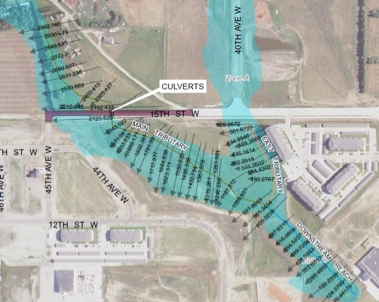
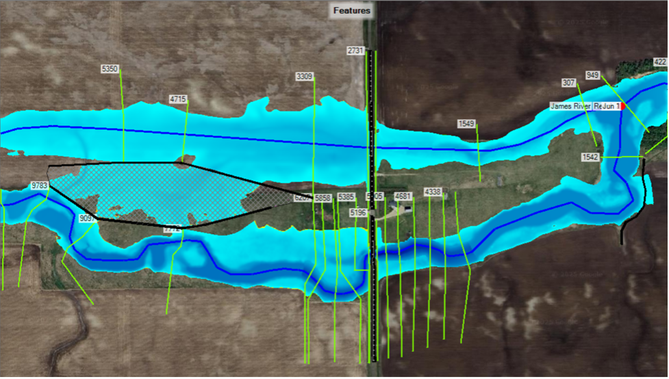
2D MODELING shows how water spreads in multiple directions across terrain, making it essential for simulating complex flooding in urban areas, flat landscapes, or overland flow conditions. One of the many uses of a 2D model is to assist in Quality Control by checking the assumptions the engineer made to flow paths in the 1D model. Here, the results of a 1D model and a 2D model are overlaid.
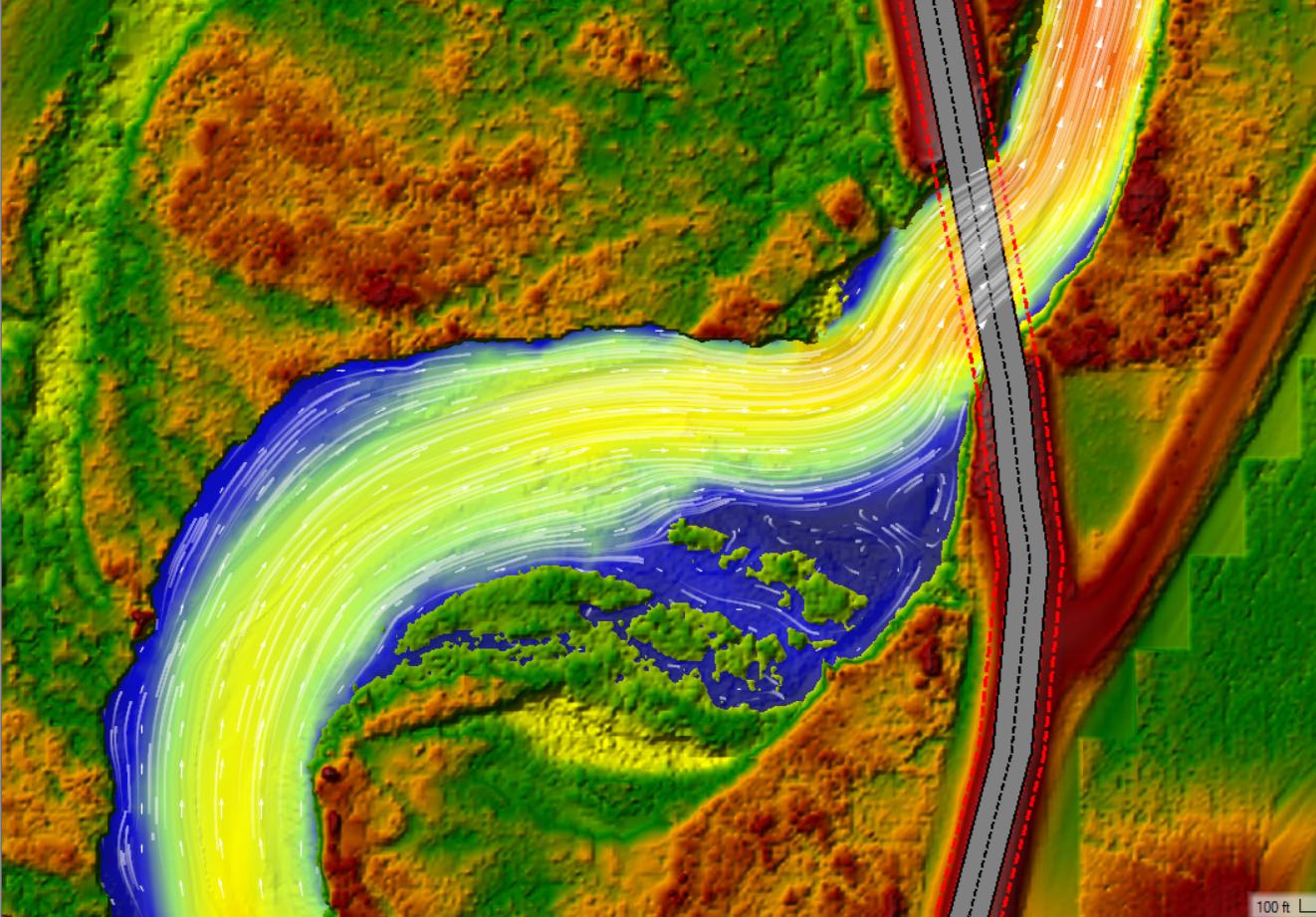
2D models also allow us to look at more detail than we could within a 1D model. Water flows through this bridge, but what is happening in the shallow upstream floodplain that is leading to erosion and putting the road at risk? Smaller flows are spinning in a circular fashion upstream (left) of the bridge. This spinning force is causing the road embankment to start falling into the river. With 2D models we can look at alternatives to redirect this flow back into the primary channel and protect the road and traveling public.
At KLJ, we often use hybrid models that combine both methods. It may be as simple as adding a 2D element to a 1D river model.
Or as complex as a fully integrated 1D/2D storm sewer model. For example, we might model stormwater pipes with 1D and surface runoff across roads and terrain with 2D. This approach captures both detailed conveyance and broader floodplain behavior. This is an increasingly standard method in modern floodplain studies.
Q: When should you use 1D, 2D, or hybrid modeling?
1D should be used for long, narrow rivers or cost-sensitive projects with simpler terrain.
2D is best when dealing with urban flooding, dam breaches, or flat landscapes where water spreads out.
Hybrid modeling will get the best of both, especially in mixed environments with both structured and open-flow areas. This method is common in modern floodplain studies to model channelized flow efficiently while capturing floodplain spreading and ponding with high fidelity. This hybrid model helps us guide our clients through the decision-making process to ensure the right balance of accuracy, efficiency, and cost.
LOOKING INTO THE FUTURE
Q: Where is the industry heading?
The future is already here. Floodplain modeling is evolving with:
- Machine learning and AI for automatic model calibration and flood forecasting.
- Real-time simulation integrated with cloud computing and emergency response systems.
- Dynamic decision support for planners and agencies managing active flood events.
KLJ is actively exploring these innovations to help our clients stay ahead of tomorrow’s water challenges.
Q: How does floodplain modeling impact real-world projects?
It’s a cornerstone of good infrastructure planning. Whether we’re helping a city prepare for the next 100-year flood or advising stormwater design for a new development, modeling gives our clients the insights they need to make confident, informed decisions.
We’ve supported municipal and federal floodplain studies, stormwater master planning, transportation design, and emergency management with reliable modeling using these models.

Q: Why should our clients choose KLJ for flood modeling services?
Our team has wide experience in the realm of modeling. Which allows us to handle the simple to complex in an efficient manner. On top of that, we have a deep experience with regulatory agencies and complex projects. We also provide in-house experts who specialize in hydraulics and hydrology. We use personalized solutions tailored to terrain, timelines, and budgets. But most importantly, our commitment to excellence and sustainable infrastructure for our communities.
We don’t just run models; we help clients understand what the results mean and how to act on them.
Learn more about our hydraulics services and projects here!
